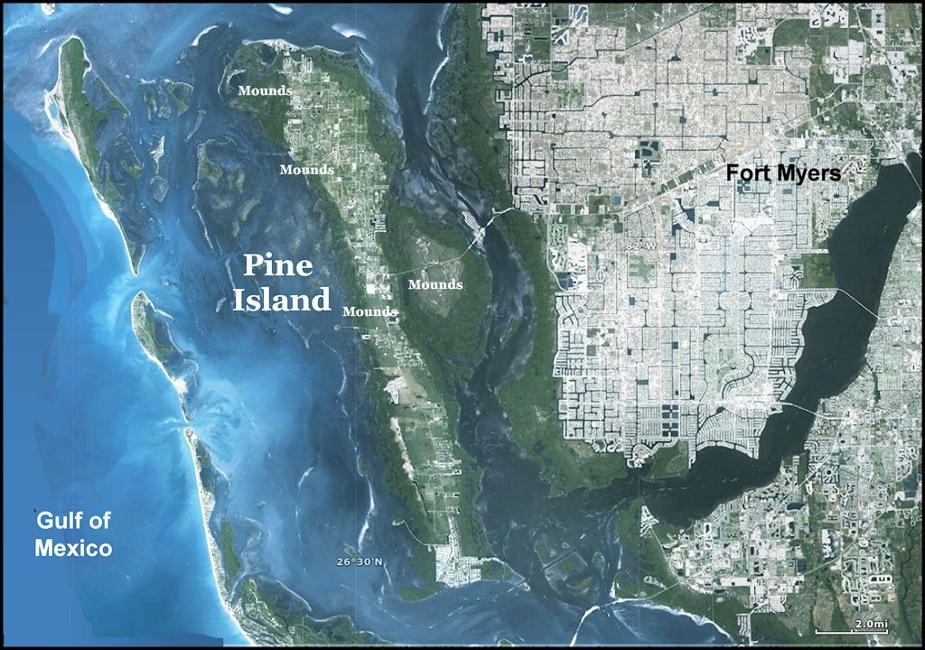
The 211 acre Pineland Archeological District was listed as a historic district on the National Register of Historic Places on November 27, 1973. It is located on Pine Island within the Pine Island Sound in Lee County, Florida. The archaeological zone is adjacent to Pine Island Sound.
The island is accessed by Florida Highway 78 from Fort Myers. The route passes over three bridges and an island composed of tidal marshes surrounded by a sandy barrier island, barely above mean sea level. The Pineland Site Complex is managed by the University of Florida Foundation, in partnership with the Archaeological Conservancy, Lee County and the Calusa Land Trust.
Pine Island is the largest island in Florida. Unlike most islands in the Ten Thousand Island region, it was created from coral rock, not accumulated sand dunes. There is no beach on the western edge. Instead a new barrier island is forming across a lagoon. This lagoon would have offered many advantages to Native American occupants of the island. The sand barrier island protected the main island from storm tidal surges, while the lagoons and channels surrounding the island would have been bountiful sources for seafood.
The shore of the Florida Peninsula extended as much as 200 miles westward during the peak glacial period of the last Ice Age. At this time, it was probably an arid grassland. By 6,000 BC, the shore was still about 20-40 miles farther west. The island began to form after seas rose further in the period around 2000-1600 BC. From then till the present era, the sea gradually rose, but there were some periods when sea level subsided slightly.
Pineland Archaeological District contains medium-to-large sized shell and sand mounds, pre-European canals, earthen platforms, artificial ponds and effigies created from sandy soil. Many small mounds and occupation sites were destroyed by real estate development during the past 150 years.
Native American Inhabitants of Pine Island

Big game hunters would have occasionally visited the locale of the future island during the Ice Age. They were followed by migratory hunters and gatherers after around 8000 BC. Around 1500 BC the shore line would have been close enough to attract people, who obtained most of their sustenance from the sea.
Pine Island was occupied an ethnic group associated with the Caloosahatchee culture from 500 BCE until after 1700. The people, who occupied Pine Island from around 0 AD onward, were probably Calusa Indians. However, much of Pine Island also showed evidence of long term occupation.
The Calusas were a maritime people with many cultural traits from South America. Their principal deity was the South American sun god, Toya. This deity was also worshiped on the southern coast of South Carolina. This suggests that the Calusa’s or relatives of theirs settled in that region too. They were fishermen, hunters and gatherers. They did maintain small gardens where small, sweet squashes, tobacco and herbs were grown. They practiced several forms of human sacrifice, the most ghastly being the sacrifice of first born children.
Calusa society was stratified into distinct classes. Close relatives of the High King were at the top of the social pyramid. Distant relatives of the king and professional soldiers formed the next class. The nobility lived on platform mounds; the higher the mound the more powerful the family. The vast majority of Calusa, were commoners who lived in large buildings that housed hundreds of people.
Early in the Christian Era, in a period called “the Roman Warm Period,” sea levels were comparable to or higher than current levels. The people of Pineland during this period left linear shell middens parallel to the shore. Several lines of middens formed as people moved back and forth in response to variations in the sea level in the Sound.
As the climate shifted into a cooler period around 550 AD, sea levels and the climate deteriorated so much that Pine Island Sound no longer supported enough seafood to support a large population on Pine Island. Ocean currents also possibly changed. This corresponds to a period of intense volcanic activity to the south in Central America. Also, in 539 AD, a large comet or meteorite struck the Atlantic Ocean between the Bahamas and Florida Peninsula. This may have caused a catastrophic decline in sea life near Florida. The quantity of sea life steadily increased from 600 AD to 800 AD.
Around 800 AD, a massive caldera erupted in Chiapas State, Mexico, destroying the city of Palenque. A chain of volcanic eruptions in Central America followed. As a result, during the 9th century, the climate in southern Florida cooled again. Pineland and other population centers along the west side of Pine Island, such as Josslyn Island and Galt Island, were abandoned in favor of sites with access to deeper water on the barrier islands. These new occupation sites included the Mark Pardo Shellworks Site and on islands on the west side of Pine Island Sound, such as Useppa.
The end of the 9th century saw a change in ceramic styles, as most pottery in southern Florida became similar to that produced around the southern end of Lake Okeechobee. This corresponded to a dramatic warming period in which the water level returned to current ranges. The population in both southwest Florida and around Lake Okeechobee became much denser.
During the 10th century, linear mounds were constructed in groups, with the earthworks oriented perpendicular to the shoreline. This site planning tradition contrasted with the earlier middens that were parallel to the shoreline. The new style mounds reached heights of up to 23 ft by about 1200 AD.
About that time, a natural waterway passing between the Brown and Randell mound complexes was altered to create the western end of the Pine Island Canal. The Smith Mound was also started in the 11th century. A pronounced cool spell, around 1100, briefly lowered sea levels. The Pineland site was apparently abandoned from before 1100 until about 1150. The Little Ice Age began around 1200 and soon began again lowering sea levels in Pine Island Sound, but never as low as during the 500s AD.
Pine Island Mound Complexes
Battey’s Landing
The heart of the Pineland site, which is now called Battey’s Landing, covered about 100 acres when visited by archaeologist Frank Hamilton Cushing in 1895. By 1989 only 20 acres remained intact, preserved by landowners Don and Pat Randell. Cushing described the site as extending about 1/4 mile inland and about ¾ mile along the shore, with raised earthen platform at least 75 to 80 acres in area. This platform probably was the location of commoner housing. Cushing stated that five “enormous” rectangular courts, enclosed by nine quadrangular foundation terraces. Lower level nobility probably lived on the foundation terraces.
A series of benches, courts and enclosures extended to the south of the main site, diminishing in size. The courts were connected to Pine Island Sound by canals. Cushing described the Pine Island Canal, leading from Pine Island Sound between two “very high shell elevations” to a court that was lower than the others. The shell mounds were probably the platforms for high level nobility. From the eastern end of the court, a canal 30 feet wide and 6 feet deep ran east into the interior of the island.
Brown and Randell Mound Complexes
Close to the shore is Battey’s Landing (8LL35). It consists of the Brown Mound Complex, with five mounds in the northwest section and Randell Mound Complex, with two mounds. The two complexes are separated by the western end of the Pine Island Canal (8LL34).
Old Mound
Southeast of the Randell Mound Complex, close to the shore, is the Old Mound, or Pineland Midden (8LL37). It is an ancient garbage midden that dates from the earliest occupation of the island.
Surf Clam Ridge Complex
Inland to the south of the canal are the Surf Clam Ridge, the Citrus Ridge, the Smith Mound, or Pineland Burial Mound (8LL36), and the Low Mound (8LL1612). These are middens and earthworks that were probably built in a different time epoch than the Brown and Randell mounds.
Adam’s Mound
Furthest inland, north of the canal, is Adam’s Mound (8LL38). It was in use for most of the Caloosahatchee Culture period, from about 50 AD until after 1700 AD.
Smith Mound
Unlike the other mounds at Pineland, which were shell middens, the Smith Mound is a sand mound with thin layers of shell, and was used for burials The Smith Mound was originally about 300 feet long and 30 feet high. It was surrounded by a pond fed by a canal which branched from the Pine Island Canal. A path wound around the mound to the summit, which was narrow but flat. Cushing observed potsherds, broken shell ladles, and human bones on the mound. The Smith Mound was constructed around 1000 years ago. Part of the mound was destroyed more than a century ago. The adjacent pond and canal were filled in. Half of the mound and the pond were preserved by its owner, Captain Smith.


