The following treaties were instrumental in establishing and defining the relationship between the United States and the Arapaho and Cheyenne Confederation. They also impacted the history of the tribe after it signed the initial treaty of 1825. As goes the typical Native American – United States relation, lands promised to the tribes usage were then encroached upon by American settlers, railroads, and government roads. The Arapaho and Cheyenne would attack these settlers and railroad workers, and would in turn be attacked by the United States Military, who by the very wording of the treaties, were suppose to be defending the Arapaho and Cheyenne. Each succeeding treaty will show the historian a shrinking land mass controlled by the Arapaho and Cheyenne.
Prior to Euro-American settlement, there was no concept of “land ownership” amongst the Arapaho and Cheyenne as we now think of it. Instead of owning land by title, with definitive boundaries and covenants, think of it as the tribes controlling the land, the resources on it, and who could or could not partake of those resources, whether it be timber, food, water, or the mere trespass upon the land. The encroachment upon their land was to them a threat to their lifestyle, as they required a large land mass per person to subside. They would defend their right to the land, as they always had, in warfare and in compromise.
Outside of listing the signers of each treaty, the treaty of 1865 included a list of individuals who were related to the Arapaho and Cheyenne Tribes and whom the confederation wished to be allotted land from the reservation of the original treaty signed in 1851. This list likely includes many half-breeds and would be considered proof of prior tribal affiliation for descendants of any of the people listed.
Schedule of Treaties
- Treaty of July 6, 1825
Treaty signed at the mouth of the Teton River: Officially recognized a friendship between the United States and the Cheyenne Nation; established trading between the Nations; and placed the Cheyenne under the “protection” of the United States. - Treaty of September 17, 1851
Unratified treaty signed at Fort Laramie, Indian Territory with many different tribes, including the Cheyenne: Established peace among the tribes present, Sioux or Dahcotahs, Cheyennes, Arrapahoes, Crows, Assinaboines, Gros-Ventre Mandans, and Arrickaras. This treaty also established the territory for the Cheyenne and Arapahos: The territory of the Cheyennes and Arrapahoes, commencing at the Red Bute, or the place where the road leaves the north fork of the Platte River; thence up the north fork of the Platte River to its source; thence along the main range of the Rocky Mountains to the head-waters of the Arkansas River; thence down the Arkansas River to the crossing of the Santa Fé road; thence in a northwesterly direction to the forks of the Platte River, and thence up the Platte River to the place of beginning. - Treaty of February 15, 1861
A treaty between the United State and the Confederated Tribes of Arapaho and Cheyenne, signed at Fort Wise, Kansas Territory: The Arapaho and Cheyenne Confederation agreed to cede all land claimed by them in the present states of Colorado, Kansas, Nebraska and Wyoming, except one reserved tract, which would be called the “Reservation of the Arapahoes and Cheyennes of the Upper Arkansas.” This reserved tract would be ceded in the treaty of 1865, less then five years later. In return the United States agreed to: Spend $450,000 by building them houses, and by furnishing them with agricultural implements, stock animals, and other necessary aid and facilities for commencing agricultural pursuits; build a mill at the cost of no more then $25,000 over 5 years. - Treaty of October 14, 1865
Called the Treaty of Little Arkansas River, this treaty was signed at a camp on the Little Arkansas River in the State of Kansas: Established “perpetual peace” between the United States and the Arapaho and Cheyenne Confederation; the tribes agreed to cede the lands set aside for them in the treaty of 1861 and to settle on a new reserve in Colorado; this cession practically covers only the reserve assigned them by treaty of February 18, 1861. The remainder of their country had already been ceded by that treaty and the cession is reiterated here only to satisfy a dispute by some of the Indians on that point; this reserve was intended only as a temporary reserve, the treaty providing that as soon as practicable a new reserve should be designated, no part of which should be within the state of Kansas. This was done by treaty of October 28, 1867, and the reserve here described was relinquished. It included part of the Cherokee and Osage lands and a portion of the public domain in Kansas. As it was never their reserve except in name, it is not shown on any of our maps; the United States agreed to issue lands of 340 acres to several chiefs of the Cheyenne for the depradations of the Sand Creek massacre, and to set aside 640 acres of land within the area specified in the treaty of 1861 for various families who were all related to the Arapaho and Cheyenne; agreed to pay $20 per annum, spread out over three payments, to each member of the Arapaho and Cheyenne confederation. - Treaty of October 17, 1865
This treaty was signed at a camp on the Little Arkansas River in the State of Kansas. This treaty recognized that the Apache tribe wished to detach itself from the Comanche and Kiowa confederation and attach itself to the Arapaho and Cheyenne confederation; the Apache agreed to the terms of the treaty done three days earlier by the Arapaho and Cheyenne; and the Arapaho and Cheyenne confederation agreed to receive and be united with the Apache. - Treaty of October 21, 1867 – Memorandum
This treaty was signed at a camp on the Little Arkansas River in the State of Kansas. This treaty recognized that the Apache tribe wished to detach itself from the Arapaho and Cheyenne confederation and attach itself to the Comanche and Kiowa confederation; and the Comanche and Kiowa confederation agreed to receive and be united with the Apache. - Treaty of October 28, 1867
This treaty, referred to by some as the 1867 Medicine Lodge Treaty, was signed at the Council Camp on Medicine Lodge Creek, Kansas. The Arapaho and Cheyenne agreed to relinquish right to occupy territory outside of the reservation being set aside for them; the Arapaho and Cheyenne agreed to relinquish the reserve set apart by treaty of October 14, 1865 and to settle upon the new reservation and peacefully coexist with the white and black settlers in the area, as well as other Indian tribes. In return the United States agreed to establish 1 school for every 30 students willing to attend, to provide a physician, farmer, blacksmith, carpenter, engineer, and miller to enable the tribe over the following ten years to establish itself in the new territory. The United States further agreed to provide various clothing for each Indian on an annual basis, as well as set aside for the tribe over the following thirty years $20,000 annually, this amount to be in lieu of the treaty of 1865. - Treaty of May 10, 1868
This treaty was signed at Fort Laramie, Dakota Territory by the Northern Cheyenne and Northern Arapaho Indians and the United States. This is the first treaty recognizing a distinct northern branch of the Arapaho and Cheyenne confederation. The Northern Cheyenne and Arapaho agreed to accept a home either on Southern Cheyenne and Araphoe reservation or on Big Sioux reservation. They became established upon the Big Sioux reservation in Dakota with the Sioux. They also agreed to cede all claim to territory outside of foregoing reserves.
After the treaty of 1868, the Northern Arapaho and Cheyenne became embroiled in the continuous Sioux hostilities with the United States, taking an active part in the defeat of Custer at Little Bighorn in 1876. They likely also resented that they had no land for themselves. Between 1881-1883 Little Chief and some of this band of Northern Cheyenne moved from the Cheyenne and Arapaho Agency, Indian Territory to the Pine Ridge Agency, Dakota Territory. Finally, in 1884, the Northern Cheyenne received their own reservation, set aside for them, by executive order, in the state of Montana, called the Northern Cheyenne Reservation.
Land Cession Maps
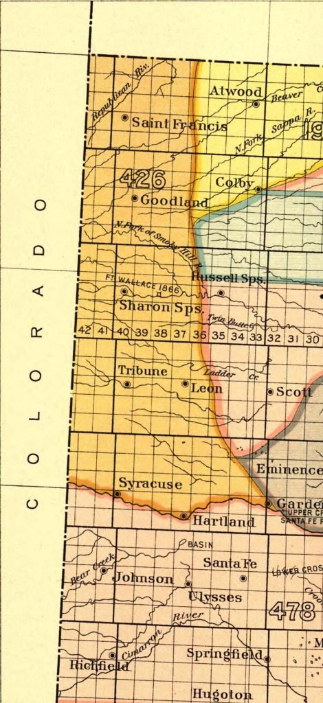
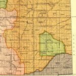
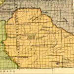
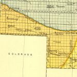
The two land cession affected by the treaties above were land cession 426 and 477. Land cession 426 was spread out over 4 different states, and we’ve provided each state as a separate image. You will find cession 477 in Colorado contained within the area covered by 426.

