The history of the Pottawatomie, even after they were in communication with the Europeans, is difficult and often obscure. Their name signifies People of the place of the fire. They came to be generally known as the Fire Nation. There is reason to believe that the Pottawatomie, the Chippewa, and the Ottawa originally formed one tribe. As one people they lived in that country about the upper shores of Lake Huron. The separation into three parts probably occurred there, and the Jesuits found them at Sault St. Marie in 1640. In 1670 the tribe or some portion of it, was living on the islands at the mouth of Green Bay. They were gathered about the Mission of St. Francis Xavier. The movement of the tribe was to the southward, and by the year 1700, or about that time, they were seated around the south end of Lake Michigan. Some of them lived far down in what is now the State of Indiana.

They were active in the interest of the French to and through the French and Indian War. In the Revolution they were on the side of the British, and they were against the United States until after close of the War of 1812. They lacked unity of action always, and when settlers crowded in upon them they scattered in various directions. They sold their lands in small lots and realized little from them. They are yet scattered abroad. By the year 1840 most of them were west of the Mississippi. That portion of the tribe which settled in Iowa became known as the Prairie band, while those in Kansas were known as the Pottawatomie of the Woods. The Prairie band first moved to the Platte Purchase, in Western Missouri, and their agency was near the present City of St. Joseph. From that point they were removed to what is now Pottawatomie County, Iowa, their chief settlement being at and about Council Bluffs. Their Kansas reservation resulted from the treaty of 1837, by which they ceded their lands in Indiana. For these they were to have a tract on the Osage River, just west of Missouri, sufficient in extent and adapted to their habits and wants. Pursuant to the terms of this treaty a tract of land about thirty-six by forty-two miles in extent was surveyed for the Pottawatomie. It was located some eighteen miles west of the Missouri line. Its south line was the north line of the lands assigned to the New York Indians, and passed about nine miles north of the present town of Iola. The north line of the tract ran about six miles south of Ottawa. The reservation contained about fifteen hundred square miles. Some of the tribe moved to this tract of land, settling along the Osage, and on what came to be known as Big and Little Osage Creeks. Also on Sugar Creek and on Pottawatomie Creek, in Miami County. The Iowa band had not disposed of the lands held about Council Bluffs. It was clear that there never could be a united nation under those conditions.

In June, 1846, a treaty was held with the two divisions of the tribe. It was concluded at the Pottawatomie Agency, near Council Bluffs, on the 5th day of June with the Iowa or Prairie band; and on the 17th of June with the Kansas band, on Pottawatomie Creek. In this treaty there was an attempt to bring together the tribes formed by the ancient division of the Pottawatomie. It provided that the various bands of the Pottawatomie Indians, known as the Chippewa, Ottawa, and Pottawatomie, the Pottawatomie of the Prairie, the Pottawatomie of the Wabash, and the Pottawatomie of Indiana, being the same people by kindred, by feeling, and by language, should unite and be consolidated into one people to be known as the Pottawatomie Nation. Their Kansas and Iowa lands were ceded to the United States. In lieu of these lands they were assigned a new reservation in Kansas, described as follows: A tract or parcel of land containing five hundred and seventy-six thousand acres, being thirty miles square, and being the eastern part of lands ceded to the United States by the Kansas tribe of Indians, lying adjoining the Shawnees on the south, and the Delaware and Shawnees on the east, on both sides of the Kansas River. This tract was the east thirty miles of the old Kansas Indian reservation. It lay immediately west of Topeka, and it comprises one of the most fertile tracts in Kansas. The Pottawatomie Nation was to move to this new reservation within two years, and certain annuities were to be paid the individuals of the Nation one year after they had settled there. The Kansas band began to move almost immediately, but it was the full two years before the Nation had assembled on the Kansas River. Some of the Kansas band settled west and southwest of Topeka. There the Baptists established a Mission, some of the buildings of which still stand.

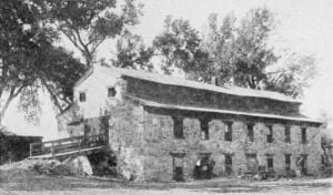
Jonas Lykins established the Baptist Mission on the reservation of the Pottawatomie. He was the brother of Dr. Johnston Lykins, of considerable note in the very early history of Kansas. Jonas Lykins had lived with the Pottawatomie on their reservation on the Osage. The activities of the Baptists there were near the present town of Osawatomie. From that point Jonas Lykins came to the new location, arriving on the 15th of November, 1847. He settled on the northeast quarter of section seventeen (17), township twelve (12), range fifteen (15), in what is now Shawnee County. In the Spring of 1848 he built a large double loghouse on the northwest quarter of section thirty-two (32), township eleven (11), range fifteen (15). In 1849 he built a two-story stone house, forty by eighty feet in dimensions, which is still standing. In 1848 the Rev. Robert Simmerwell, his daughter Sarah, and Miss Elizabeth McCoy, arrived at the Baptist mission. They organized and taught a school for the Pottawatomie children. Mr. Simmerwell was a blacksmith, and in 1848 set up a shop to follow his trade. After Lykins, the superintendents of the mission were Mr. Saunders, Mr. Alexander, Rev. John Jackson, and Rev. John Jones.The Catholics also founded a mission among them. This mission was at the junction of the three forks of the Wakarusa. It had been commenced on Sugar Creek, on the old first Kansas reservation, in 1837, by Father Christian Hoecken. He came north with one of the first parties, and in 1847 began the erection of mission buildings at the forks of the Wakarusa, in 1847. Some twenty log cabins were erected at that point. It was soon discovered that the mission was south of the reservation line, and on the Shawnee land. As the Pottawatomie could not collect their annuities until they had moved on to their own land, they abandoned their houses and moved north of the Kansas River. The Catholic Fathers established themselves at a beautiful site, now the town of St. Mary’s. The mission has grown into one of the principal Catholic institutions of the West. While the Pawnee had agreed to retire beyond the Platte as early as 1834, they seem to have been possessed of a determination to hold the valley of the Kansas River. No sooner had the Pottawatomie settled themselves about the mission at St. Mary’s than the Pawnees began attacks upon them, intending to expel them, or at least hoping to make the new home so uncomfortable the Pottawatomie would abandon it. But the old Algonquian stock was ever courageous. The Pottawatomie accepted the challenge. They declared war on the Pawnees, and dug up the tomahawk. The Pawnee force was camped along the Big Blue, down which stream they always came to make war on the enemies in the valley of the Kansas. The Pottawatomie attacked at the Rocky Ford, in what is now Pottawatomie County. A fierce skirmish ensued, in which the superior firearms of the Pottawatomie gave them the advantage. While the Pawnees were not defeated, they did retreat from the field, passing westward to Chapman’s Creek, where they made a stand. There they had a better country for the free movements of their horses, in their peculiar tactics. The Pottawatomie pursued, and when they came up with their foes a considerable battle ensued. The Pawnees had only horsemen, and at the Rocky Ford only mounted Pottawatomie had engaged them. The Pottawatomie had determined to settle once for all whether they could live on the Kansas, and had mustered their full strength, many on foot. These latter were stationed in some short bushy ravines under a high steep bank. The Pottawatomie horsemen so maneuvered that the Pawnees were drawn down the prairie along these gullies, when the Pottawatomie footmen lying in ambush there opened fire. The Pawnees were taken by complete surprise. Several of their foremost warriors were slain, but they did not give up the battle, which was fiercely contested with the mounted Pottawatomie, who were now much encouraged. They charged the Pawnees repeatedly, finally putting them to flight. The Pawnees disappeared northward over the prairies, and never more made a foray below the Big Blue. The Pottawatomie were never more molested by them. They lost some forty warriors in this effort to drive out the Pottawatomie. For many years a Pottawatomie chieftain who had distinguished himself in this campaign would decorate himself in true warrior style on the anniversary of the battle and ride to the western and northern boundary lines of the reserve to celebrate the victory and satisfy himself that their frontiers were clear.The Pottawatomie have the social organization found in the tribes of the Algonquian family. The clans or gentes of the tribes are as follows:
- Wolf
- Bear
- Beaver
- Elk
- Loon
- Eagle
- Sturgeon
- Carp. (Golden Carp.)
- Bald Eagle
- Thunder
- Rabbit
- Crow
- Fox
- Turkey
- Black Hawk
The Pottawatomie made a treaty in 1862 under which the greater portion of their reservation was disposed of. There was a disagreement in the tribe on the subject of land. The Prairie band refused to accept their land in severalty, and severed their relations with the other bands. They were given a reservation in common eleven miles square in Jackson County, Kansas, a part of the old home tract, and now reside upon it. It was provided that the other bands should or might become citizens of the United States and have their lands allotted to them. There was a surplus after the allotment, and this went through the usual process of graft in the final extinction of the Indian title.
In 1868 the Citizen Pottawatomie secured a reservation in what is now Oklahoma, to which they moved, and where they now live.


