Perhaps the most striking feature of all in the natural history of the modern Pamunkey comes before us in the survival of the controlled hunting and trapping rights: the custom by which each hunter in the band controls an assigned and definitely bounded area within which he enjoys the exclusive privilege of setting his traps for fur-bearing animals. Various phases of the practice of hunting and trapping within restricted boundaries have attracted attention among certain Algonquian Indians, to such an extent that the custom may be regarded as forming a more or less typical institution, with varied local associations, among the northern branches of the stock. Before discussing the significance and authenticity of the Pamunkey case, however, I shall first present purely descriptive material.
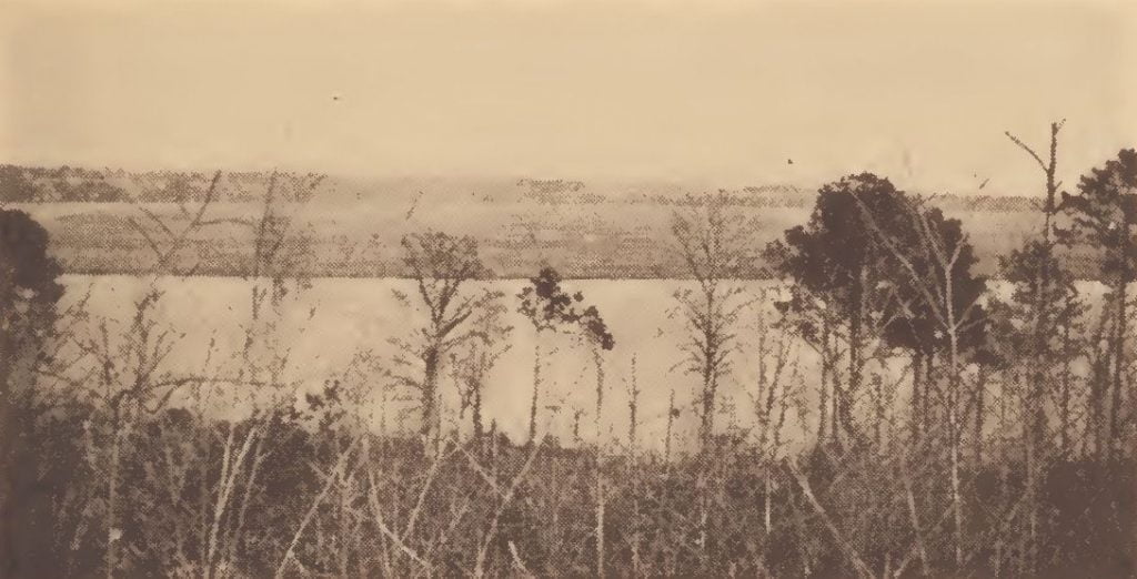
The present diminutive Pamunkey reservation of about 900 acres contains two kinds of land. There is a dry arable tract of about 300 acres which is completely under cultivation for the usual crops of corn, sweet potatoes, and other staple crops of this part of Virginia’s coastal plain. The district that interests us, however, is approximately 600 acres of virgin forested swamp. The usual arborescent growth of the freshwater swamp of this latitude is most strikingly exhibited over the whole area. The swamp-gum, the sour gum, the swamp oak, maple, magnolia, hackberry, poplar and their smaller associates, crowd every foot of the floor of this swamp, the only tree lacking to make it thoroughly coastal Carolinian being the bald cypress. The cypress seems to be represented by only a few scattered clusters and individual trees at several spots along the Pamunkey, though it is noticeably abundant beginning at the next river southward, the famous Chickahominy. When the ancestors of the Pamunkey, about 1658, chose to reserve this particular tract along the river for their final domain, it must have been with a clear vision of their future need of a territory where natural inaccessibility would provide a haven for game more or less permanent and, to the agencies of the day, indestructible. The swamp extends for a distance of from 4½ to 5 miles along the river and encircles about four-fifths of the island-peninsula which comprises the territory where the Pamunkey descendants still operate their own form of political and economic control.
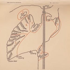
Aside from its natural interest the swamp has a distinct historical background, having been from earliest traditional information divided into the same six hunting tracts that we find still recognized in the native land-laws of the tribe. These six tracts are separated by the intervals between certain well known creeks, or lagoons, “guts” as they are locally termed, which wind their way some distance through the interior fastnesses of the swamp and open out into the river. In each of these tracts one of the Pamunkey hunters enjoys the right of pursuing his hunting and trapping activity without competition, and free from trespass by his neighbors. These tracts and the lagoons are shown with their names and general contortions in a sketch by Paul Miles, one of the hunters, in conference with his associates and the chief. Such a chart, I may add, had never been made before by them; accordingly they showed no little interest in preparing it. It is presented, after redrawing for reproduction, the only addition to its original form being the lettering.
- The lagoon and marshes at the mouth of Wash han creek, including the shore westward as far as the railroad bridge, constitute the hunting plot which we number one, known as the Wash han grounds. The name is supposed to come from ”wash hands.” On the eastern border the privilege of use stops at the edge of a white man’s land. This territory has been for several years operated by Tecumseh Cook, a son of the chief. There is little more to be said of it, except that some high pine woods are included in it, and that raccoons and muskrats are the principal product.
- An extensive grassy marsh, separated by a few hundred feet from the shore, is known as Dock or Docks Island from the plenitude of dock, the favorite food of the muskrat, which grows on and about it. Trapping there yields an abundance of muskrats. The place is a resort of ducks in the fall and winter. These grounds are worked by Paul Miles.
- Adjoining number one, beginning on the shore at the railroad bridge, hunting ground number three follows the shore around the big cove and landing place on the western side of the reservation, and takes in the waters of Great creek and Small creek. Great creek is its major lien. The division line on the southern and western edge is between Otter wallow and Turkey creek. Great creek is a fairly rich plot and yields muskrats abundantly to its proprietor. Ducks seek refuge in its murky channels and turkeys are frequently shot from roost out of the gum trees which overshadow it. This has also been controlled for some years by Paul Miles.
- Beginning with Turkey creek and taking in several productive lagoons, called Crooked, Spring and Bills creeks, is a rather extensive forested swampy district terminating at Hanger’s gut. It is considered more than a mile in extent from the river back to high land. This is worked by Ezekiel Langston, who is rewarded principally by an abundance of muskrats, raccoons, and otters; he supports himself entirely by fishing, hunting, trapping, and corn rising, as do the other four families whose men operate hunting grounds.
- What is considered to be the largest ground extends from Hanger’s gut to Swetts landing, taking in Hog-pen and Cornfield creeks, and Maple, Deep, and Raccoon guts. This is leased by Tecumseh Cook.
- The small tract of timber swamp and marsh from Joe gut to Williams creek is trapped by Jim Bradby.
There are besides a number of other families who live by the same industry which they ply at large for the want of specific territories.
In one case at least among Algonquians in the north the custom was followed of marking off the boundaries of inherited family hunting territories by birch-bark signs. But here in Virginia no indication of boundary signs occurs, for none is needed. The creeks dividing the plots are so well known that almost any boy of Pamunkey town can name and locate them. Furthermore there are no social associations involved in the possession of the hunting grounds, for they are not now inheritable, nor does tradition at Pamunkey point to an earlier different or more complicated situation. We shall probably never know whether or not the grounds were originally inherited in families. Each year the six hunting grounds are disposed of by lease to any applicant in the tribe who pays the rental. The decision and right of assignment rest in the hands of the chief and council. Generally in spring the annual assignment is made. A somewhat similar case incidentally is reported for the Nova Scotia Micmac. The tracts lease nowadays for about forty dollars each. Often one hunter will acquire two grounds, yet sometimes all will not be rented, which of course is advantageous, for then the next year’s supply of game is replenished after a season of repose.
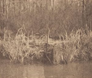
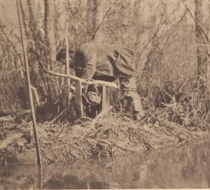
The proprietary privileges include the use of the old deadfall trap sets which are placed in the most favorable spots on all the grounds (fig. 47). These are the heavily constructed log-and-stake cabin deadfalls set in the muddy runways where muskrats and raccoons pass by to reach their feeding stations.
Year after year these traps do their work, requiring little repair, and some of them may still be seen where they are known to have stood since the Civil War. That the stationary deadfalls are aboriginal Pamunkey properties there is little doubt. The natives prefer them to the modern steel-traps because they do not rust, they never allow game to escape minus a leg, and they do not damage the fur. I shall describe them in more detail in another place.
In short we meet here another case of the phenomenon exhibited widely among the northern Algonquians. The case at hand is no more elaborate and yet no less fundamental economically than what is generally the normal thing in the northern Algonquian culture where hunting is dominant and where native institutions have escaped annihilation. The principal question arising is, How could it have so escaped in Virginia after several centuries of English contact?
Whatever skeptical argument may be brought forth with the intention of nullifying the importance of the Pamunkey circumstances in a study of Algonquian economic institutions, we have to consider the following confirmatory facts:
- The institution of the hunting territory is an inseparable factor among the Algonquians proper where the chase is vital.
- We already have before us instances where the social pattern has been adjusted to a paternal exogamic type of society, as it appears among the Ojibwa, as well as to a maternal clan organization as among the southern New England tribes, although material illustrating the latter has not yet been presented in print.
- The hunting territory, from its general distribution and its fundamental character, crops out in different Algonquian areas under modifications which, however much they may diverge, are confined within such limitations as can be well understood through consideration of environmental factors.
A certain deduction would seem to emerge then from our survey: that the hunting institution is a fundamental and an old Algonquian trait. Hence the case presented by the Pamunkey is a normal one except for some unusual facts, chief among which are that the Pamunkey have lost so much of their cultural background; that their habitat is so distant from other Algonquians possessing the feature in question; that the practice of agriculture was on an equal footing with that of hunting. It is furthermore somewhat puzzling that an Algonquian institution so weakened by the rival activity of agriculture, even in early times, should have survived the decline of native culture so long. On most of these matters, however, there is some room for discussion.
A search through the narratives of the early Virginia explorers fails to yield any definite information on the existence of restricted hunting grounds among the Powhatan tribes of the time. Yet the remarks of Captain John Smith on the hunting practices of the tribes of the low country might apply as well to the people of the lower St. Lawrence valley who carry on an annual movement from their settlements along the coast to their hunting grounds in the interior.
While the following statement from Captain Smith is not explicit on the questions of inheritance and privilege, it at least alludes to a form of territorial subdivision which we recognize at once and may build upon:
But this word Werowance which we call and conster [construe] for a king, is a common worde whereby they call all commanders: for they have few words in their language and but few occasions to use any officers more then one commander, which commonly they call werowances. They all know their sever all lands and habitations, and limits to fish, fowl, or hunt in, but they hold all of their great Werowances Powhatan, unto whom they pay tribute of skins, beads, copper, pearl, deer, turkies, wild beasts, and corn.” 1
In a subsequent chapter on fishing customs mention will be made of the location rights which were recognized in the placing of weirs or fish-traps near the headwaters of the Pamunkey and Mattaponi rivers. This is one of the few instances where we find such regulations on the Atlantic coast, though they are fundamental among the northwest Pacific coast groups. Information coming from the Wabanaki tribes of the northeast seems to point to a similar but weakened control of fishing stations in the salmon area. 2
John Smith again (1612) says:
”They leave their habitations and reduce themselves into companies and go to the desert places with their families where they spend their time in hunting up toward the mountains by the heads of their rivers where there is plenty of game. For betwixt the rivers, the grounds are so narrow that little cometh there which they devourer not.” 3
He adds the statement that they travel three or four days’ journey from their habitations, which would carry them say 50 to 80 miles from the Chesapeake Bay line. We may imagine their best hunting grounds then to have been in the general region of the falls-line between the Piedmont and the Coastal plain, along the line from Washington to Richmond. Captain Smith refers in other places to the scarcity of game in the inhabited portions of Powhatan’s country as due to the size of the native population. The present Powhatan survivors in Virginia reside well up toward the rising land in what would be near the western frontier of their habitat in the period when the Monacan tribes occupied the foothills of the eastern Blue Ridge. They evidently chose their best hunting resorts for their final abode. I think it quite a plausible assumption, moreover, that certain Indian district names encountered today at many points along all the low-country rivers are reminders of the old hunting district names.
In the survival of the reduced hunting-grounds arrangement at Pamunkey after the country was taken over by the English, the situation reproduces what has developed among some of the Ojibwa bands of the Lakes region. On the Gull Lake reservation in Minnesota, for instance, when some years ago the White Earth band was moved from its reserve and placed with the Gull Lake band, the resident population at Gull Lake had to share its hunting lands with the newcomers. As a consequence the original Gull Lake districts which had been under inherited family proprietorship were, under the pressure of economic invasion, obliged to be reduced in size very considerably to provide hunting grounds for the aliens. It may accordingly be surmised that, with the occupancy of their extensive original domain by the English at the close of the seventeenth century and their assignment to the small reservation on the river, the Pamunkey recast their hunting arrangements to coincide with the reduced area, portioning the available land of the reservation into miniature hunting grounds based on the old plan. So it may be construed, at least in accordance with the natural likelihood of the case both from external and internal evidence. For the latter the following may be considered:
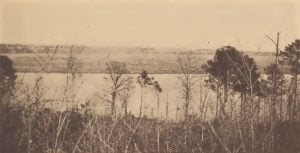
If the above explanation of the change which has taken place be accepted as tentatively adequate, we can understand, by its aid, the reason for some of the present district names applied to prominent locations on Pamunkey River, as well as upon the neighboring rivers in Virginia which were inhabited by tribes of close affinity. The Indian names of these reaches of the river and of some of the points on its shores are still known in the neighborhood. These are extremely interesting. Just below the reservation is an extensive marsh and forested swamp known as Cohoke, a name of fixed usage applied both to the grassy marsh and to the swamp which is picturesquely ”Cohoke low-ground.” Cohoke is clearly the original native district name. Although Cohoke is owned by whites, it still harbors an abundance of game which the Pamunkey regularly draw upon, especially the deer which they take by the drive and canoe, a method to be described later. Farther down on the north shore of the river is also Takhoman (tak‛whóman in the Pamunkey pronunciation). This is a farm on very fertile land where the presence of archeological refuse attests a former Indian family settlement. On the opposite shore of the river is Coosiak. Opposite the reservation is Rickahock, a name common to each of the four rivers of tidewater Virginia at some particular reach of its course. Below still on the northern shore near the railroad station of Romancoke is the region known among the Pamunkey by the name Uttamussak, an old name appearing in the records as Powhatan’s ”temple” site and marked on Captain Smith’s map of 1608. On Mattaponi river are similar locality names, and again on Chickahominy and James rivers. Some of those on Chickahominy River undoubtedly perpetuate Smith’s nomenclature.
My point, in short, is that these place names may be reminders of old geographical designations for former hunting territories. District names also occur attached to the family hunting territories among the Indians of the interior Province of Quebec.
When it is learned that a form of the characteristic Algonquian hunting territory institution is still in practice among the Pamunkey, we might well wonder what are the circumstances in which it could have been perpetuated among the Powhatan descendants until this day; for it is scarcely to be expected that successful hunting could be waged by an Indian band in a region like modern tidewater Virginia. Suspicion has accordingly already been expressed of its being a modern development in this particular instance. But if we examine probabilities I think we may be finally as much inclined to regard the whole thing here as a native survival as to regard it as being the expedient of more recent economic conditions.
In considering further the occurrence of the hunting-territory institution in Virginia, it might be expected to have graded off to extinction in time and place so remote from the sources of contact with those regions and conditions which gave it existence and where it still flourishes as a phenomenon associated with hunting and not with agriculture. In seeking the nearest area where even a partly agricultural Algonquian tribe exhibits the expected feature, we are at a loss to settle upon the direction of search. Northeastwardly the Massachusett and Narragansett of southern New England undoubtedly had their own modified form of the institution, since something akin to it was recorded by Roger Williams. This I have discussed as a proved case in a separate paper. 4 But westward toward the habitat of the Central Algonquians, where many features of material culture, and no doubt of social life, had analogies with those of the Powhatan group, we have a surprising meagerness of evidence that the territorial division was observed in any region south of the Ojibwa of Minnesota. Both Dr. Michelson and Mr. Skinner profess to have met with indications of its former provenience among the Sauk and Fox, but no more instances are forthcoming in spite of their intensive knowledge of this culture area. Further search may still reveal its memory, as I suspect will possibly be the case, or else it has gone by the board among the Kickapoo, Potawatomi, Menomini, and the other central divisions through the acculturation of economic agencies connected with agriculture more enduring and more forcible than the uncertain activities of the chase.
Some of the dubious qualities of the case just mentioned are, however, answerable. One objection arising against the originality of the hunting grounds at Pamunkey, in particular, becomes weakened by evidence directly at hand in Virginia. To attribute the inception of the hunting-grounds custom among the Pamunkey exclusively to an imitation of the whites is manifestly a surmise aimed in the wrong direction, for white hunters and trappers in colonial times, and now as well, in the Southern and Middle states are not known to have had the slightest knowledge of such a policy of operation. In the past, as well as now, they have been characterized as unconfined wide-ranging pioneers and fur-traders throughout. The remark might be added that only in the northern regions, where practically all the native tribes, both Algonquian and Athapascan, show the territorial division among hunters as a fundamental trait of procedure, do we find white trappers adopting the custom. While it accords completely with the efficient arrangement of the Hudson’s Bay Company and other legitimate and conservational trading concerns throughout the entire north, it would probably be wrong to deny that the policy was originally derived from the Indians themselves and built upon their economic methods.
Hence the Pamunkey custom becomes worthy of being regarded as somewhat more authentically native in its conception, evidently being an old Algonquian heritage which, like other vagrant practices recorded among the aberrant southern branches of the family, has earned, through its practicability, the right to survive two culture pressures a southern agricultural contact in the purely Indian period of history, and later the holoclastic European culture impact.
In respect to the antiquity of the hunting-grounds division at Pamunkey, we have very little documentary testimony beyond the records preserved among the papers of the chief and council which I have consulted. These show decisively that the assignment of hunting plots, the same in boundaries as those now recognized, goes back as far as the early part of the last century.
In the above account I have attempted to convey the impression of the whole development as progress was made in acquiring and coordinating the information concerning hunting grounds at Pamunkey. It might be added that my experience here was rather similar to that which I recall in working with the nomadic hunters of the far north. Some months elapsed before I became aware that regulations existed in the Pamunkey band. Slowly the matter came to light after several months’ contact, during which time frequent hunting and trapping excursions had been made with one of the proprietors. My impression is at present fairly positive that the Powhatan tribes, like their Algonquian kindred farther north, operated their hunting industry on a general plan of segregation and privilege. So henceforth in our survey of American economic features the Powhatan culture area deserves to be indicated in a fairly well-established light as having possessed a sporadic form of the hunting-territory institution, to an extent certainly as positive as has been shown only recently for the northern California peoples. We may wonder if some vestiges may not yet be found among records pertaining to the Delawares beyond what MacLeod has produced.
Citations:
- Smith’s account of Virginia in Tyler, L. G., Narratives of Early Virginia, New York, 1907, p. 115. The italics are Speck’s.[↩]
- The writer’s unpublished manuscript on the Malecite of New Brunswick.[↩]
- Smith’s account of Virginia in Tyler, L. G., Narratives of Early Virginia, New York, 1907, pp. 103-104.[↩]
- Territorial Subdivisions and Boundaries of the Wampanoag, Massachusett, and Nauset Indians, Indian Notes and Monographs, misc. no. 44.[↩]

