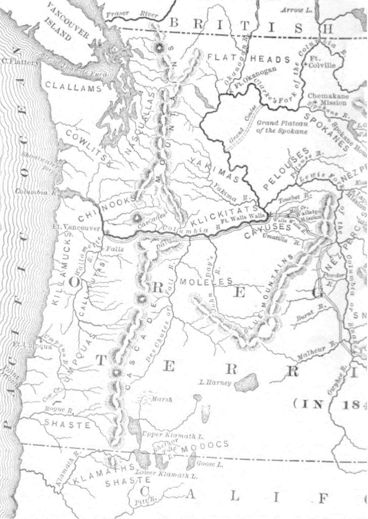
We will now leave New Mexico for a time and see what is being done in Oregon. As we make this change of position let as examine the country and its inhabitants, in a general way. Suppose we can rise in the air to a convenient height and take a bird’s-eye view of the entire region. We are now over the southeastern corner of the mountain country. Directly north from as runs the great continental divide, until it reaches about the 48th parallel of latitude, just west of the site of the future city of Cheyenne; there it turns to the left and trends northwest to our boundary. The foothills, which occupy only a narrow strip of country between the main range and the plains as far north as parallel 41, bear gradually to the east above that point, thus leaving a great triangular body of comparatively low mountain land, east of the continental divide, for the northeastern corner of our region. It will eventually form Western Dakota and nearly all of Wyoming and Montana. West of the divide the country is separated into four great natural divisions. The farthest from us is the immediate slope of the Pacific, cut off from the great central basins by the Sierra Nevada and Cascade mountain ranges, which follow the general contour of the coastline. This division will hereafter make California and the western parts of Oregon and Washington Territory. At about parallel 42 of north latitude we see an immense, transverse watershed crossing the central mountain region from the Rockies to the Sierra Nevada. To the north of it the country is drained by the tributaries of the Columbia, a noble stream, which breaks its way through the Cascade Mountains and flows to the Pacific. Idaho, with the eastern parts of Oregon and Washington Territory, will be carved from this section. On the south side of the transverse watershed lie the great Utah basin and the valleys of the headwaters of the Rio Colorado, separated by the Wahsatch Mountains at about longitude 111° west of Greenwich (the western line of Wyoming) as far south as 37° of north latitude, where this watershed turns to the west at a right angle and continues to the Sierra Nevada. The Utah basin includes the future state of Nevada and western Utah. The land drained by the Colorado system will be known after some years as Eastern Utah, Western Colorado, and Arizona. The artificial divisions of the mountain country, as we look at it, are very simple. All the country east of the divide is embraced in Missouri Territory and New Mexico, which are separated by the Arkansas River. West of the divide likewise there are two sections, Oregon and Upper California, separated by parallel 42 of north latitude.
There are few whites in the country as yet. There is a little settlement at Pueblo, on the Arkansas, a considerable colony of Mormons southeast of the Great Salt Lake, and a few ranches in California. Aside from the scattered forts and trading posts, we see no more establishments of white men except in Oregon, where they are almost wholly west of the Cascade Range. The natives find their tribal boundaries to a large extent in the natural ones mentioned above. On the neighboring plains to the east of us are the Kiowas and Comanches. North of them, on the plains near the mountains, are the Cheyennes and Arapahoes, ranging from the Arkansas to the Platte. To the north again, along the border of the foothills, is the numerous Sioux or Dakota family, extending to our northern boundary and far to the east. Parts of the great northeastern triangle are inhabited by the Crows and the Assinaboines, who are of the Dakota family; the Blackfeet, who, like the Cheyennes, are a branch of the great Algonquin family of the East; and the confederated Minnetarees or Hidatsa, Ricarees (Arikaras, Rees) or Black Pawnees, and Mandans, the latter a strange tribe, believed by many to be descendants of Madoc’s Welsh colony of the twelfth century. The southeastern part of the triangle is a common battleground for the surrounding tribes, who, though nearly all related, are hostile – a veritable dark and bloody ground, over which the besom of destruction swept again and again both before and after the whites entered it. On the Pacific coast the principal families are the Chinooks and Nasquallas, of Oregon, and the California Indians. From the Rio Colorado to our point of observation, the Pima nation dwells, and the tribes of Apaches and Navahos, whose language identifies them with the extensive Athabascan family of British America. In the lapse of years they, as well as the Umpquas of western Oregon, have been separated from their northern brethren, and are also much changed in character, our New Mexican neighbors being very demons in their daring and fierceness, while the Tinné, or northern Athabascans, are mild and timid. Nearly all the remainder of the mountains is held by the great Shoshonee stock, which includes many tribes. Of these the Shoshonees proper, or Snakes, live on the Snake River, south of the Salmon Mountains; the Bannocks (Bonacks, Panocks) south of the Snakes, on the same stream; and the various tribes of the Utahs (Youtas, Ewtaws, or Utes) hold the Utah basin and the headwaters of the Colorado. The Modocs of Southwestern Oregon are related to them, as are also the Kiowas and Comanches. These latter tribes have separated from their relatives over the most natural roadway across the mountains, southeast from The Dalles of the Columbia to the South Pass. (It now forms the route of a proposed railway to connect Oregon with the Gulf of Mexico, the building of which is only a question of time.) It is the same road that Dr. Whitman followed with his emigrants. We will follow it into his missionary field of Eastern Oregon, the only part of the central reg

